Homesteaders at Boggy Bayou and Rocky Bayou
(A section of the NICEVILLE, FLORIDA - Online History Center)
"History is a kind of introduction to more interesting people than we can possibly meet in our restricted lives; let us not neglect the opportunity.”~Dexter Perkins
Some of the original homesteaders and landowners along Boggy Bayou and Rocky Bayou:
Allen Brown, Jr. received his homestead on January 27, 1900, Lot 3 of Section 7 and Lot 2 of Section 18 in TIS of R22W containing 159.75 acres along the water on the West side of Boggy Bayou.
Warren Armstrong received his homestead on April 9, 1901, Lot 4 SW ¼ of SE ¼ Section 6 and Lot 2 Section 7 TIS of R22W containing 153.30 acres, along the water on the East side of Boggy Bayou. The Nathey Gristmill was located on this property.
Elizabeth Edge received her homestead on April 9, 1901, Lot 1 of Section 13 in TIS of R23W containing 138.25 acres along the water on the West side of Boggy Bayou. On August 6, 1901 she sold her homestead to John F. Allen.
Photo below of homesteader William John Nathey and his wife, Mary Jane Bolton Nathey.
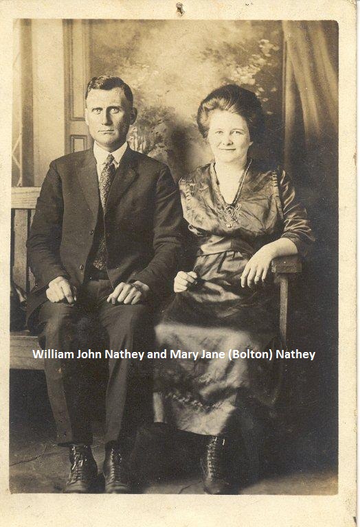
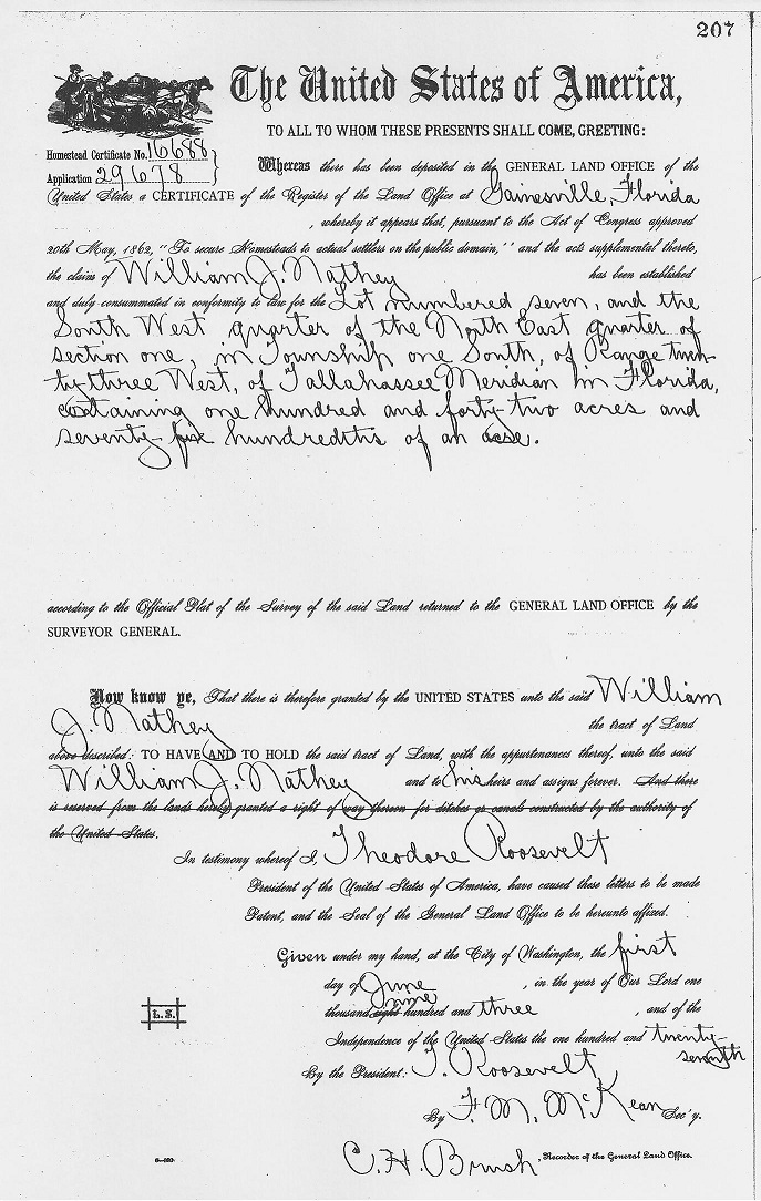
William John Nathey received his homestead on June 1, 1903, Lot numbered 7, and the SW 1/4 of the NE 1/4 of Section 1, in T1S, of R23W, of Tallahassee Meridian, containing 142.75 acres at the head of Boggy Bayou.
Samuel Lee Lancaster received his homestead on August 30, 1904, Lot 4 and the N ½ of Lots 5 & 6 of the N ½ of SW ¼ Section 15 TIS R22W, containing 149.77 acres on Rocky Bayou.
Simeon W. Burlison received his homestead on December 20, 1904, Lots 3 & 4 Section 9 TIS R22W for 149 acres on Rocky Bayou.
Nathey Homestead Certificate, (June 1, 1903)
Lewis (Louis) Early received his homestead on September 28, 1904 for the East half of the SE quarter, the NW quarter of the SE quarter and the SW quarter of the NE quarter of Section 8 in T1S of Range 22W containing 160.26 acres located between Boggy Bayou and Rocky Bayou.
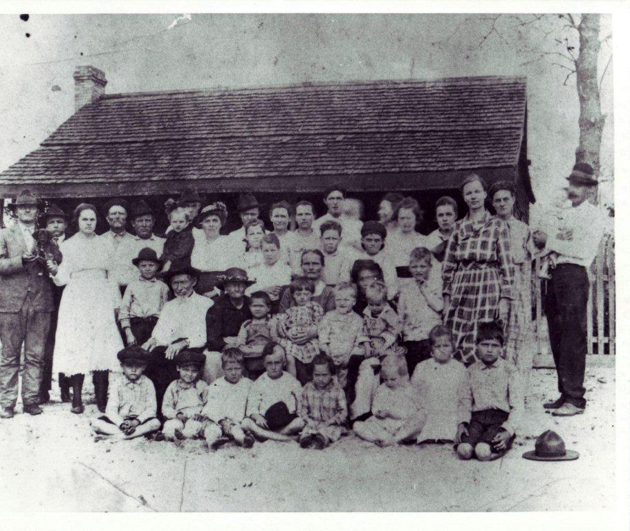
James T. Bolton received his homestead on June 30, 1905 for Lot 3 Section 11 T1S R22W for 48.18 acres on Rocky Bayou.
The photo below is of the Bolton Family circa 1920: Homesteader James T. Bolton and his wife Rebecca (Ward) Bolton are seated near the center of the photo on the left side.
Aaron H. Howell received his homestead on June 4, 1906 for the NW quarter or the lots numbered 2 and 3 of Section 12 in T1S of R23W containing 160 acres located on the west side of Boggy Bayou.
Francis C. Eaton received his homestead on June 13, 1906 for the North half of the NE quarter and the North half of the NW quarter of Section 6 in T1S of Range 23W containing 159.69 acres along the water on the west side of Boggy Bayou.
Jacob E. Early received his homestead on August 9, 1907, Lot 4 of Section 19 in T1S of R22W containing 111 acres located along the water on the south side of Weekly Bayou and west side of Boggy Bayou.
George W. Parrish received his homestead on January 13, 1908, the SW quarter of the SW quarter of Section 8, the West half of the NW quarter of Section 17, and Lot 1 in Section 18 in T1S R22W containing 147.31 acres along the water on the east side of Boggy Bayou. : (Note: His homestead bordered the 40 acre Boggy Mill complex to the North that was located on Lot 5 of Sec 7, Tp. 1 South, Range 22 West).
Francis C. Eaton purchased 205 acres of public land on May 11, 1908 at Lot 6 Section 1 Lot 1 of Section 12 TIS R23W, containing 205 acres adjacent to his homestead along the water on the West side of Boggy Bayou.
Mitchell Hancock purchased 153.52 acres of public land on October 26, 1908 for Lot 2 and the West half of the SE quarter of Section 14 T1S R22W along the water on Rocky Bayou.
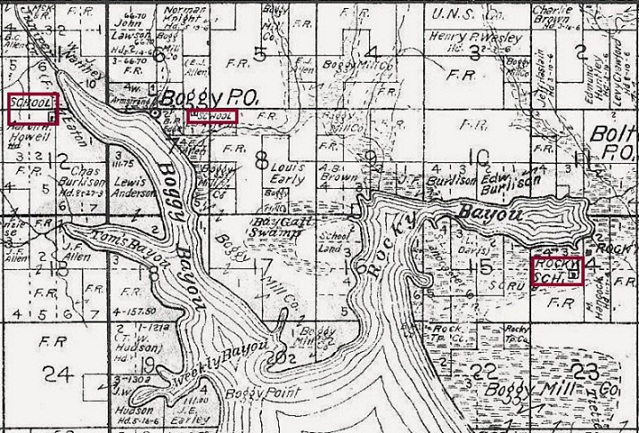
A portion of Boggy Precinct #9 from the 1908 Walton Co., Farm Map showing some homesteaders in Boggy, Florida.
Elisha J. Allen received his homestead on May 7, 1909 for the East half of the SE quarter Section 6, Lot 1 of Section 7, and the NW quarter of the NW quarter of Section 8 in T1S of R22W containing 160 acres along the water on the East side of Boggy Bayou.
Benjamin C. Allen received his homestead on September 20, 1909 for the NE quarter of Section 2 in T1S of Range 23W containing 160 acres on the West side of Boggy Bayou near Juniper Creek.
John T. Bolton received his homestead on October 6, 1910 at North half of the NE quarter and the SW quarter of the NE quarter of Section 11 in T1S R22W containing 120.69 acres located at the head of Rocky Bayou. This land is located adjacent to the 48.18 acres in the same section he received in 1905.
Thomas W. Hudson received his homestead on November 3, 1910 for Lot 1 and the South half of Lot 2 or the SW quarter of the NW quarter of Section 19 in T1S of R22W containing 160 acres along the water on the North side of Weekly Bayou and West side of Boggy Bayou.
John J. Allen received his homestead on April 5, 1911 for the West half of the NW quarter, the SE quarter of the NW quarter, and the NE quarter of the SW quarter of Section 2 in T1S of R23W containing 160 acres located to the west of Juniper Creek adjoining land of Benjamin C. Allen.
Photo below of homesteader James Burlison on left.
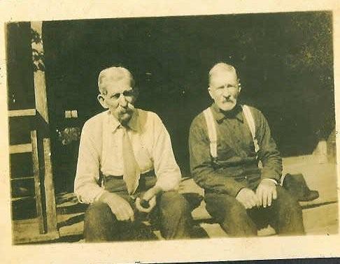
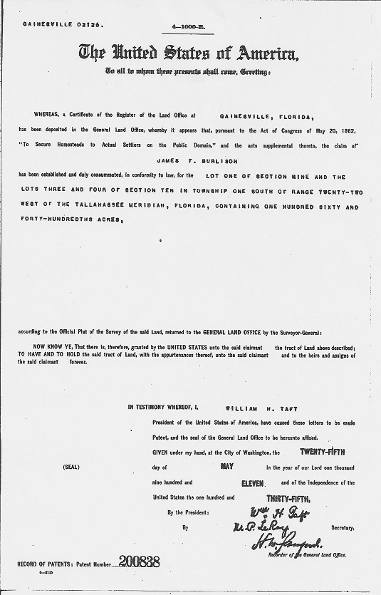
James F. Burlison received his homestead on May 25, 1911, Lot 1 of Section 9 and Lots 3 and 4 of Section 10 in T1S of R22W containing 160.49 acres along the water on the North side of Rocky Bayou.
James F. Burlison Homestead Certificate, (May 25, 1911)
The Homestead Act of 1862:
The Homestead Act, enacted during the Civil War in 1862, provided that any adult citizen, or intended citizen, who had never borne arms against the U.S. government could claim 160 acres of surveyed government land. Claimants were required to “improve” the plot by building a dwelling and cultivating the land. After 5 years on the land, the original filer was entitled to the property, free and clear, except for a small registration fee. Title could also be acquired after only a 6-month residency and trivial improvements, provided the claimant paid the government $1.25 per acre. After the Civil War, Union soldiers could deduct the time they had served from the residency requirements. Although this act was included in the Republican party platform of 1860, support for the idea began decades earlier. Even under the Articles of Confederation, before 1787, the distribution of government lands generated much interest and discussion. The act, however, proved to be no panacea for poverty. Comparatively few laborers and farmers could afford to build a farm or acquire the necessary tools, seed, and livestock. In the end, most of those who purchased land under the act came from areas quite close to their new homesteads (Iowans moved to Nebraska, Minnesotans to South Dakota, and so on). Unfortunately, the act was framed so ambiguously that it seemed to invite fraud, and early modifications by Congress only compounded the problem. Most of the land went to speculators, cattlemen, miners, lumbermen, and railroads. Of some 500 million acres dispersed by the General Land Office between 1862 and 1904, only 80 million acres went to homesteaders. Indeed, small farmers acquired more land under the Homestead Act in the 20th century than in the 19th. (Information excerpted from Teaching with Documents: Using Primary Sources From the National Archives. [Washington, D.C.: National Archives and Records Administration, 1998], p. 31. And from Milestone Documents [Washington, DC: The National Archives and Records Administration, 1995] pp 56-55.